
Posted on Feb. 8, 2026 at 12:24 am
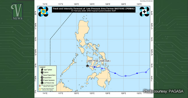
Tacloban City — The low-pressure area (LPA) previously named Tropical Depression “Basyang” (international name: Penha) dissipated on Saturday morning, February 7, 2026, according to Philippine Atmospheric, Geophysical, and Astronomical Services Administration (PAGASA).
As of 8 a.m., the LPA no longer poses a threat, and PAGASA has confirmed that there are no other low-pressure areas currently being monitored for potential tropical cyclone formation. The public is advised to stay informed through official announcements from PAGASA.
Basyang, which had strengthened into a tropical storm, caused heavy rains and flooding in Caraga and parts of the Visayas from Thursday night to Friday.
In the latest Tropical Cyclone Bulletin No. 23F issued at 5 a.m., the LPA was last located 105 kilometers southeast of Cuyo, Palawan (10.1°N, 121.6°E), moving westward at 25 km/h with a central pressure of 1006 hPa. No tropical cyclone wind signals were raised.
PAGASA also cautioned about strong to gale-force winds due to the northeast monsoon affecting much of Luzon, Western Visayas, Negros Island Region, and Zamboanga del Norte.
Residents are reminded to remain vigilant and follow weather advisories, especially regarding the heavy rainfall forecast in Weather Advisory No. 32. — Nicole Cabacang, BS DevCom Intern, The Vanguard

 Government Agencies Provide Relief to Tacloban Coastal Communities Affected by Balikatan Drills
  New Minimum Wage Now in Effect Across Eastern Visayas
  More than 100 Motiong residents receive livelihood aid from DOLE
  Eastern Visayas Records 234,000 voter applications for 2026 polls
  Tourism brings more livelihood opportunities to Limasawa residents
  Eastern Visayas Power Crisis Prompts Demands for Accountability