

 Gina Dean
 Posted on October 16, 2026 at 4:51 am

The ongoing struggle surrounding the proposed Vena Energy wind power project in Calbayog City resembles a high-stakes game of cat and mouse—a continuous scramble where environmental advocates must expose covert developments before irreversible damage is inflicted on Samar’s fragile ecosystems.
Uncovering Covert Plans Above Sacred Headwaters
Local coalition groups—including the Tinambacan Environmental Advocates Coalition (TEAC) and the Samar Multi-Sectoral Environment Advocates (SAMSEA)—recently uncovered alarming plans to construct massive wind turbine generators directly above Tarangban Falls and along the border of the Calbayog Pan-as Hayiban Protected Landscape (CPHPL).
Beyond turbine placement, scheduled tree clearing for access roads poses an immediate threat to vital watershed cover. As Prof. Harold Mercurio of the Samar Island Heritage Center noted, the strategy by Singapore-based Vena Energy appears calculated: had local vigilance wavered, heavy equipment would already be breaking ground unchecked.
What exactly did Vena Energy’s geotechnical teams discover during their soil and water testing that makes them stubbornly insist on placing turbines in these ecologically sensitive locations?
Administrative Illusion vs. Environmental Accountability
To address these site-level concerns, advocates petitioned the Regional Development Council (RDC VIII) for an urgent oversight probe, highlighting a troubling pattern: a project driven primarily by procedural compliance rather than genuine ecological care or community participation.
The Misplaced Infrastructure & Procedural Flaws
Volunteer planners identified 15 turbines inside the vital Calbayog Watershed—12 sitting dangerously close to the perimeter of CPHPL, and 3 situated in the upper catchment directly above Tarangban Falls, putting local hydrology at immediate risk.
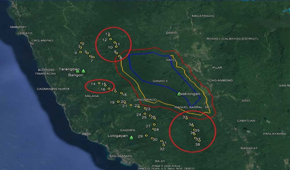
A consultation held on August 12, 2026, promoted as a demonstration showing how heavy turbine blades would be transported, amounted to nothing more than a basic ocular site inspection. No transport equipment or turbine components were present, and the essential Malaga Jetty had not even been built.
During the public hearing on August 13, 2026, organizers gathered attendance on generic signature sheets lacking formal document headings, creating fear among residents that sign-in lists could be manipulated as community backing for a logistics trial that never occurred.
When developers failed to produce 3D overlay maps detailing road networks, ridge elevations, and turbine footprints relative to downstream channels, TEAC-SAMSEA requested RDC VIII to authorize an independent LiDAR drone survey through the Department of Science and Technology (DOST) to model upstream hydrological impacts.
The Technical, Environmental, and Socio-Economic Toll
According to Dr. Ronald Orale, an expert in Water Resource Engineering, placing wind turbines on upper forest ridges is heavily contested across several critical grounds:
The Calbayog Pan-as Hayiban Protected Landscape (CPHPL) was legally established to safeguard the forested catchment supplying the city’s drinking water. Canopy clearing and heavy topsoil compaction on upper ridges drastically reduce natural groundwater infiltration, directly threatening the deep aquifers that feed essential springs.
Earthworks located just 300 to 400 meters uphill from headwater tributaries strip existing protective vegetation. This elevates the runoff coefficient and accelerates surface runoff, shortening concentration times to 2.66. During heavy rain events, flushed silt cascades down natural drainage channels, discoloring and polluting iconic eco-tourism destinations such as Tarangban and Bangon Falls.
Transporting massive 165-meter turbine components requires extensive cut-and-fill access roads along steep slopes via serpentine engineering. This heavy infrastructure footprint expands land disturbance far beyond the immediate road corridors, increasing landslide risks and stripping critical forest cover—a hazard that persists even if turbine towers are positioned outside the core protected boundary.
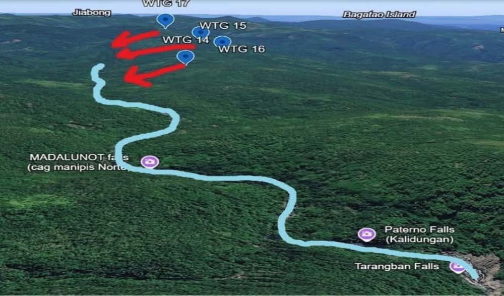
The region’s underlying limestone (karst) geology features deep subterranean fissures and cavern systems. Construction runoff carrying silt and industrial chemicals flows directly into these karst formations, corrupting deep groundwater aquifers and jeopardizing the primary drinking springs of host communities like Danao, Malaga, Nakilingan, and Cagnipa.
Flawed Empirical Basis in the Environmental Impact Assessment (EIA)
The developer’s Environmental Impact Assessment relies on theoretical models and single-visit observations rather than multi-season empirical research. Without multi-season streamflow metering, continuous rainfall tracking, and thorough water quality testing, claims of “low to moderate” environmental impact remain unverified by actual hydraulic proof.
Socio-Economic Inequity and Disproportionate Risk
The project imposes a stark socio-economic imbalance on local residents. While carbon reduction offers global environmental benefits, 100% of the ecological sacrifice—degraded watersheds, heightened risk to drinking supplies, and ruined natural monuments—is borne locally, with no guarantee that generated power will lower regional electricity rates rather than being exported to Luzon for private profit.
Inverting the Mitigation Hierarchy
At its core, this controversy exposes a fundamental flaw in the project’s Environmental Impact Assessment (EIA), where standard environmental protection protocols were effectively inverted. Rather than prioritizing total avoidance by first evaluating lower-sensitivity landscapes—such as degraded brushlands or agricultural areas—the developer selected intact forested watershed ridges as its primary choice, opting merely to micro-shift individual turbines to remain barely outside legal boundaries. Furthermore, instead of conducting a rigorous, receptor-based analysis to map specific downstream impacts on local springs, waterfalls, and community water supply networks, the proponent relied on broad regional characterizations, attempting to minimize damage within a high-value ecosystem rather than avoiding sensitive headwaters altogether.
Deflection Over Leadership
While citizens actively mobilize to protect Calbayog’s 17 wind turbine generator sites and fragile eco-tourism zones, the local government unit remains strikingly silent. Rather than addressing public concern or demanding accountability from the proponent, local authorities shifted blame onto church leaders for “making noise” following a Eucharistic Mass held at the foot of Bugtong Falls in Barangay Tinaplacan. This persistent passivity only fuels growing public suspicion, forcing residents to question whether the project is already a done deal behind closed doors. When public officials choose deflection over transparency while natural watersheds and protected lands hang in the balance, citizens must demand clear answers, as the eco-tourism landmarks and protected biodiversity of Samar cannot be quietly traded away without genuine public consultation, rigorous scientific review, and strict environmental accountability.


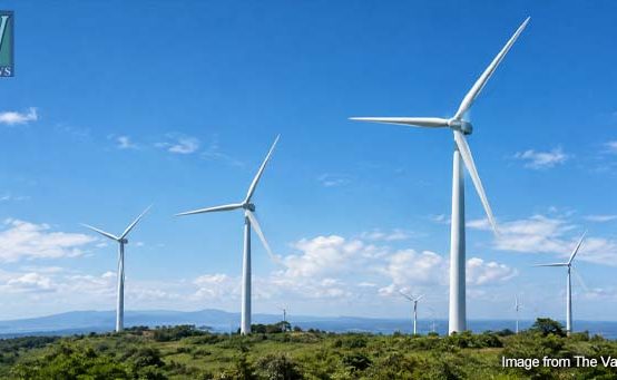 Who Holds the Reins? Calbayog Pushed to the Margins in a 20-Billion Renewable Energy Venture (3/3)
  Catbalogan City Declared Peaceful and Stable
  Drug Suspect Arrested, 7 Shabu Sachets Seized in Catbalogan
  Calbayog LGU, SAMELCO I Discuss Rising Power Rates
  Catbalogan Walang Gutom Kitchen to Serve 400 Meals Daily Starting October