
 Jazmin Bonifacio & Christian Ray Torres
Part 2: MAPPING THE CORRIDOR
Following the Route: Ports, RoRo Terminals, Highways and Municipalities
The Pacific Drop Zone: Tracing the Drug Trade Through the Waters Off Eastern Samar
Posted on November 06, 2026 at 10:57 AM

In January 2023, authorities intercepted a shipment of shabu near the Port of Allen in Northern Samar. More than three years earlier, police had seized nearly 89 kilograms of the same drug from two vehicles in Gandara, Samar.
Along Eastern Samar’s Pacific coast, meanwhile, fishermen have repeatedly found packages of cocaine floating in the water.
The incidents happened in different places and under different circumstances. There is no established evidence linking them. But taken together, they raise questions about how illegal drugs move through Eastern Visayas and how authorities monitor the region’s extensive network of roads, ports and coastal waters.
Eastern Visayas occupies an important position in the country’s inter-island transport network. Ferries connect Luzon to Northern Samar across the San Bernardino Strait. From Allen, vehicles can travel south through Samar, cross San Juanico Bridge into Leyte and continue toward ports serving routes to Cebu, Mindanao and other destinations.
Every day, these roads and ferry terminals carry passengers, private vehicles, buses, trucks and commercial cargo.
They keep people and goods moving between the islands. But when illegal drugs are concealed in vehicles or freight, authorities face the challenge of identifying suspicious shipments without disrupting legitimate travel and commerce.
In an interview, Coast Guard District Eastern Visayas commander Captain Alvin B. Dagalea discussed the difficulties of monitoring the region’s coastline and the possibility that ferry terminals and inter-island routes could be used to transport illegal drugs.
His account provides insight into the Coast Guard’s maritime security concerns.
Records from the Philippine National Police (PNP), the Philippine Drug Enforcement Agency (PDEA) and other government agencies offer another way to examine the issue. These documented seizures can be considered alongside the region’s road and maritime connections to better understand where authorities have intercepted drugs and what questions remain unanswered.
The goal is not to label every port or highway a drug route. It is to examine what the documented cases reveal, identify areas that may require closer scrutiny and determine what additional information is needed to understand the movement of illegal drugs across the region.
ALLEN: THE GATEWAY FROM LUZON
For motorists and freight operators traveling from Luzon to Samar, Allen in Northern Samar serves as one of the main entry points.
Ferries connect Allen to Matnog, Sorsogon, across the San Bernardino Strait. From there, vehicles can continue south along Samar’s highway network toward the southern part of the island and the bridge connecting Samar to Leyte.
The route carries a steady flow of passengers and cargo.
For law enforcement agencies, the challenge is to identify suspicious vehicles and shipments without holding up legitimate traffic.
A drug interception on January 31, 2023, brought this concern into focus. Authorities seized about 10 kilograms of shabu near the Port of Allen, with an estimated value of P68 million, according to reports.
PDEA reported that the suspect had allegedly transported the shipment from Luzon toward Mindanao. The agency also described the region’s nautical highway as a transshipment route for illegal drugs.
The reported destination is significant. It suggests that Eastern Visayas may have been part of a longer journey, rather than the intended market for the shipment.
However, the seizure does not establish that the drugs entered the country through Allen or were carried aboard a particular ferry. What the available reports establish is that authorities intercepted the shipment near a major transport connection while it was reportedly being moved from Luzon toward Mindanao.
Another operation near Allen in March 2023 resulted in the recovery of shabu worth approximately P7 million from a vehicle. A Philippine Coast Guard drug-detection dog was also requested to assist in the inspection.
The two incidents involved separate operations, but both drew attention to vehicles passing through the Allen area.
They also highlight the importance of information-sharing among enforcement agencies. Intelligence reports, vehicle inspections and K9 assistance can help authorities determine which shipments require closer examination.
Allen’s significance lies in its location between a major ferry crossing and the road network connecting Northern Samar to the rest of Eastern Visayas.
That makes the area relevant to drug investigations. It does not mean, however, that every vehicle passing through the port is suspicious or that the port itself is regularly used for smuggling.
To establish how a shipment moved through this corridor, investigators would need to determine where it boarded or left a ferry, how it traveled by road and where it was supposed to go.
THROUGH SAMAR: THE ROAD SOUTH
From Allen, vehicles can travel south along the Pan-Philippine Highway, passing through towns and communities across Samar before reaching San Juanico Bridge.
For residents, the highway is part of everyday life. It connects communities to markets, schools, hospitals and workplaces. Businesses also rely on it to transport goods between municipalities and across provincial boundaries.
The same road network becomes relevant to drug investigations when authorities receive information about vehicles suspected of carrying illegal substances.
One of the region’s largest recorded drug seizures happened in October 2019, when police recovered approximately 88.49 kilograms of shabu from two vehicles in Barangay Buñagan, Gandara, Samar. The drugs were valued at around P600 million at the time. The operation was reported as the largest drug seizure in Eastern Visayas.
According to PDEA, the shipment was reportedly intended for Cebu. Investigators had received information about the vehicles’ movements and their arrival through ports in Northern Samar before intercepting them in Gandara.
The case drew attention to Samar’s position between the ferry crossings in the north and the wider inter-island transport network farther south.
It also showed how intelligence gathered about a vehicle’s movements could help authorities intercept a suspected shipment before it reached its reported destination.
The Gandara operation was not simply a case of recovering drugs from two vehicles. Investigators also examined information about the vehicles and how they had traveled through the region.
Still, the case has its limits. It documents one shipment and the route authorities associated with it. It does not prove that all drugs entering Northern Samar pass through Gandara or that the ports mentioned in the investigation are regularly used for drug trafficking.
The case raises a practical question: When authorities receive information about a suspicious vehicle at a ferry terminal, how effectively is that information passed on to police and enforcement units farther along the highway?
Answering that question requires coordination among the PNP, PDEA, the Coast Guard and other agencies. It also requires reliable information about vehicles, their movements and the circumstances that prompted an investigation.
Without effective coordination, information gathered at one point along the route may not reach the personnel who need it farther down the road.
SAN JUANICO BRIDGE: THE CONNECTION TO LEYTE
South of Gandara, the highway continues toward San Juanico Bridge, which spans the strait separating Samar and Leyte.
The bridge is one of Eastern Visayas’ most important road connections. It allows vehicles to travel between the two islands without boarding another ferry and forms part of the Pan-Philippine Highway.
In examining a possible drug shipment, the bridge helps illustrate how a vehicle could travel from Northern Samar through Samar and into Leyte as part of a longer journey.
But its location along the highway does not prove that it was used in any particular drug shipment.
The cases examined for this report do not establish that the shipments intercepted in Gandara or Allen crossed San Juanico Bridge as part of their documented journeys.
That distinction matters. A map can show how places are connected, but it cannot establish the actual route taken by a specific vehicle without supporting evidence.
To reconstruct a suspected shipment’s journey, investigators may need to examine witness accounts, vehicle records, checkpoint reports, ferry information and other available evidence.
These details can help establish whether a vehicle passed through a particular municipality or crossed into another province. They can also help determine whether separate drug seizures have anything in common.
For now, San Juanico Bridge is best understood as an important connection within the regional transport network, not as a confirmed drug-trafficking location.
LEYTE: PORTS, ROADS AND THE NEED FOR BETTER INFORMATION
Leyte is another important part of the corridor.
Tacloban, the regional center, is connected to Samar through San Juanico Bridge. Roads across Leyte link communities, commercial areas and ports that handle passenger and cargo traffic.
The Philippine Ports Authority lists Tacloban as a base port under the Port Management Office for Eastern Leyte and Samar.
Other port facilities serve communities such as Borongan, Calbayog, Guiuan and San Isidro, while the Port of Ormoc falls under the port management office responsible for Western Leyte and Biliran.
These ports support local economies and connect communities to other parts of the country.
Their presence, however, does not establish that they are being used to transport illegal drugs into Eastern Visayas.
The documented seizures offer a more concrete starting point.
In the Gandara case, authorities reported that the vehicles carrying shabu had arrived through ports in Northern Samar before traveling south.
In the Allen case, a separate shipment was reportedly being transported from Luzon toward Mindanao when authorities intercepted it.
Both cases show why information about port arrivals and subsequent road movements can be important in reconstructing a shipment’s journey.
They do not establish a direct connection between those incidents and every port in Leyte.
To determine whether other ports have figured in similar cases, investigators would need to examine individual seizure records, shipping information, vehicle movements and other supporting evidence.
Port traffic figures and inspection records would also help show how much screening takes place and what resources are available to authorities.
The issue is not simply how many ports operate in the region. It is whether authorities have enough information to identify suspicious movements, coordinate inspections and follow up on reports as vehicles travel between islands.
SOUTHERN LEYTE: THE ROUTE TOWARD MINDANAO
Farther south, Southern Leyte provides another important connection in the country’s inter-island transport network.
Captain Alvin B. Dagalea, commander of Coast Guard District Eastern Visayas, identified San Ricardo as one of the important checkpoints in efforts to address the possibility of drugs being concealed in vehicles using the region’s roll-on/roll-off (RoRo) system.
RoRo services allow vehicles to board ferries and continue their journeys by road after reaching another island.
The system makes travel and freight transport more convenient. But it also means that inspections at ferry terminals can form part of a wider effort to detect illegal cargo.
A vehicle carrying drugs may pass through several transport links before reaching its destination. Information gathered at one terminal may therefore be useful to personnel at another checkpoint or port.
The information available for this report does not establish a specific drug seizure at San Ricardo that can be linked to either the Gandara or Allen cases.
Its relevance lies in its position within the regional transport network and the need to examine how vehicles and cargo are screened at the southern end of the corridor.
Several questions remain unanswered.
What inspection equipment is available at the terminal? How often are K9 teams deployed? Which agencies conduct inspections, and how do they share information about suspicious vehicles? Are there records showing how quickly officers respond when a concern is reported?
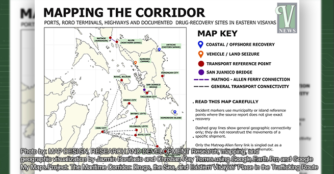
EXPLORE THE MARITIME CORRIDOR THROUGH OUR INTERACTIVE MAP
Click on the markers to discover reported drug seizures across Eastern Visayas and read the stories behind the numbers
MAP DESIGN, RESEARCH AND DEVELOPMENT Research, mapping, and geographic visualization by Jazmin Bonifacio and Christian Ray Torres using Google Earth Pro and Google My Maps. Project: The Maritime Corridor: Drugs, the Sea, and Eastern Visayas’ Place in the Trafficking Route
The Vanguard | 2026© The Vanguard. All rights reserved.
Answers from the agencies responsible for these operations would help establish the extent of current inspection coverage and whether additional resources are needed.
The routes connecting Southern Leyte to Cebu and Mindanao are important to the wider investigation. But the role of any particular route in a drug case must be established through evidence, not inferred from its location.
CEBU AND MINDANAO: THE REPORTED DESTINATIONS
Two major drug seizures in Eastern Visayas illustrate why investigators must look beyond the places where drugs are recovered.
In the October 2019 Gandara case, authorities reported that the shabu shipment was intended for Cebu. In the January 2023 Allen case, PDEA said the suspect was allegedly transporting the drugs from Luzon toward Mindanao.
The reported destinations indicate that both shipments were part of journeys extending beyond the areas where authorities intercepted them.
But the cases happened more than three years apart and involved separate shipments.
Available information does not establish that the incidents were connected or that the same group was responsible.
To establish a link, investigators would need evidence pointing to common suspects, recipients, transport arrangements or other details connecting the cases.
Until then, the incidents should be treated separately.
Their significance is that Eastern Visayas has figured in drug investigations involving shipments reportedly bound for other parts of the country.
A seizure in Samar may have implications for an investigation in Cebu, while a case near Allen may involve a reported destination in Mindanao.
This makes coordination across provincial and regional boundaries important. Information about a shipment’s origin, movement and intended destination may be held by different agencies in different locations.
THE PACIFIC COAST: A DIFFERENT KIND OF DRUG DISCOVERY
Drug cases involving vehicles and highways are only part of the picture.
Along Eastern Samar’s Pacific-facing coast, authorities have repeatedly reported finding cocaine in coastal waters or along shorelines.
Northern Samar has also recorded a case involving shabu recovered along the shoreline of Biri Island.
These incidents differ from vehicle interceptions. When drugs are found floating at sea or washed ashore, authorities may not know how long the packages have been in the water, where they entered it or who was supposed to retrieve them.
The recovery site establishes where the packages were found. It does not, by itself, establish their origin or intended destination.
Despite these limitations, the incidents provide a record of repeated drug discoveries along parts of Eastern and Northern Samar’s coastlines.
2009-2010: COCAINE RECOVERIES ACROSS EASTERN SAMAR
Reports from 2009 and 2010 documented substantial cocaine recoveries in waters off Eastern Samar.
The reported recovery areas included Llorente, San Policarpo, Maydolong, Balangkayan, Sulat, Dolores, Salcedo, Mercedes, Arteche, Taft and Borongan City.
Published accounts differ on the total number of cocaine bricks recovered during this period. One account reported 226 bricks in 2009 and nine in 2010, while other reports described a larger recovery involving nearly 300 bricks.
These figures should not be combined without checking the original reports and determining whether they refer to the same incidents.
What remains consistent across the accounts is that cocaine was recovered in several locations along Eastern Samar’s coastline.
The reports do not establish that all the packages came from one vessel or belonged to a single trafficking operation.
They do, however, provide an early record of maritime drug recoveries in an area where fishermen and other coastal residents regularly work.
The incidents also raise questions about how authorities documented the discoveries, searched for additional packages and investigated the circumstances surrounding each recovery.
2018: COCAINE FOUND IN GUIUAN
In 2018, authorities recovered 25 bricks of cocaine around Sulangan and Homonhon Island in Guiuan, Eastern Samar. The packages were reported to be worth more than P31 million.
The discovery brought renewed attention to the province’s coastline, several years after the earlier incidents.
But the recovery alone did not establish where the cocaine came from or where it was supposed to go.
Answering those questions would require additional evidence, including available information about vessel movements and the circumstances surrounding the discovery.
The 2018 case adds another documented recovery in the area. It should not be treated as proof that the incidents in 2009-2010 and subsequent years were part of one continuing operation.
2019: SHABU FOUND ALONG BIRI ISLAND
On August 10, 2019, a fisherman and a teenager found five packages containing approximately 9.71 kilograms of shabu along the shoreline of Biri Island, Northern Samar.
The drugs were estimated to be worth around P64 million.
Unlike the cocaine recoveries in Eastern Samar, this incident involved shabu found along Northern Samar’s coast.
Police cautioned that the place where the packages were discovered did not necessarily mean the drugs were intended for Eastern Visayas.
That distinction remains important.
Finding a shipment along a shoreline does not establish where it came from or where it was supposed to be delivered. Without additional evidence, investigators cannot reliably determine its intended destination from the recovery site alone.
The case nevertheless highlights the importance of reports from coastal residents.
Fishermen and other people working near the water may come across suspicious packages before authorities know that anything has entered the area or gone missing.
Their reports give investigators an opportunity to secure the packages, document the discovery and look for evidence that may help establish their origin.
2024: THE ARTECHE COCAINE DISCOVERY
On March 8, 2024, a fisherman found 20 bricks of cocaine floating in the coastal waters of Arteche, Eastern Samar.
Authorities confirmed that the packages contained approximately 21.19 kilograms of cocaine, with an estimated value of P111.85 million.
The discovery prompted a coordinated response involving the police, the Philippine Coast Guard and other enforcement personnel. Authorities monitored the surrounding waters and searched for additional packages.
The case brought renewed attention to earlier cocaine recoveries along Eastern Samar’s coastline. It also highlighted the difficulties of investigating suspected offshore deliveries when no vessel or intended recipient has been identified.
Authorities considered possible explanations, including international transshipment. However, publicly reported information did not conclusively establish where the cocaine came from or where it was headed.
Investigators also did not establish a connection between the 2024 recovery and the incidents in 2009–2010 or the 2018 Guiuan case.
The repeated discoveries warrant closer examination of the circumstances surrounding each recovery. But they do not, on their own, prove that one trafficking group has been using the same route for more than a decade.
TWO DIFFERENT ROUTES, TWO DIFFERENT INVESTIGATIONS
When the documented cases are examined alongside Eastern Visayas’ transport network, two distinct enforcement concerns emerge.
The first involves drugs transported in vehicles along ferry-connected highways. The Allen and Gandara cases show that authorities have intercepted shabu from vehicles near a major transport gateway and along a highway in Samar.
The second involves drugs recovered from coastal waters or shorelines.
The cocaine discoveries in Eastern Samar and the shabu recovery on Biri Island show that suspected contraband can be found even when authorities have not identified the vessel involved or established where the shipment was headed.
These incidents involve different drugs, locations, dates and circumstances. They should not be presented as evidence of one connected trafficking network.
They do, however, point to different investigative needs.
For vehicle-related cases, investigators may need to examine ferry records, vehicle registrations, checkpoint reports, witness accounts and evidence about a shipment’s intended destination.
For packages recovered at sea, investigators may need to examine the packaging, circumstances of discovery, available vessel-movement records and other evidence that could help establish where the packages came from.
Although the investigations may require different methods, both depend on accurate documentation, timely reporting and cooperation among the agencies involved.
WHAT THE COAST GUARD IS DOING
Captain Dagalea’s account provides a picture of the measures the Coast Guard is taking to improve maritime monitoring and address possible trafficking risks.
He described the installation of shore-based very-high-frequency (VHF) radio repeaters designed to extend two-way communication to about 15 to 18 nautical miles offshore.
He also discussed the activation of the Southeastern Samar station and the establishment of Coast Guard outposts on Homonhon and Manicani islands.
These stations give the Coast Guard a more direct presence in strategic island areas, while improved radio communications help personnel maintain contact with vessels operating near the coast.
Dagalea also identified the National Maritime Center and the PCG Command Center as important facilities for monitoring vessel movements across the country’s Exclusive Economic Zone.
When monitoring personnel detect unusual Automatic Identification System (AIS) patterns or other suspicious vessel activity, they can relay information and coordinates to regional units for assessment and possible interception.
These systems can help authorities identify vessels that warrant closer attention.
However, an unusual tracking pattern does not, by itself, prove that a vessel is carrying illegal drugs. Further checks and investigation are needed to establish what the vessel is doing and whether enforcement action is warranted.
At ferry terminals, Dagalea identified Allen in Northern Samar and San Ricardo in Southern Leyte as important checkpoints in efforts to detect drugs that may be concealed in vehicles.
He also discussed the use of specialized detection dogs and the PCG’s practice of breeding and training its own working dogs through the PCG K9 Academy in Pampanga.
K9 teams can help identify vehicles or cargo that require further inspection. Their work complements other screening measures and intelligence gathered by enforcement personnel.
These measures address different parts of the problem.
Radio communications allow personnel to exchange information, island outposts provide a local presence, centralized monitoring helps direct attention to unusual vessel movements, and K9 teams assist with vehicle inspections.
None of these measures can guarantee that every suspicious shipment will be detected.
Their effectiveness depends on the information available, the number of personnel on duty, the equipment at each location and the ability of different agencies to coordinate their response.
WHERE ARE THE GAPS?
The documented cases identify places where drugs have been recovered or intercepted. But they do not provide a complete picture of how effectively the region’s ports, highways and coastlines are being monitored.
That assessment requires information not yet available in the records reviewed for this report.
How many vehicles and passengers pass through the main RoRo terminals each day?
Which terminals have K9 teams, scanning equipment or other inspection facilities?
How often are vehicles inspected?
How many personnel are assigned to major checkpoints?
Which coastal areas have limited patrol coverage?
Response times also matter.
When a fisherman reports a suspicious package in a remote coastal barangay, how long does it take authorities to reach the area?
What procedures are followed to secure the package and document the discovery? How is information about the incident shared with investigators?
These questions require answers from the Coast Guard, PNP, PDEA, port authorities and ferry operators.
Inspection logs, staffing records, response-time data and individual case files would help establish where enforcement efforts are concentrated and where additional resources may be needed.
The number of seizures alone cannot provide that assessment.
A location with numerous recorded seizures may also be an area where authorities conduct frequent inspections or receive more reports.
Meanwhile, a location with few recorded cases may have less drug-related activity, fewer inspections or gaps in reporting. Without additional data, it is difficult to determine which of these explanations applies.
Similarly, the absence of a reported seizure does not establish that a particular route is free from risk.
A clearer assessment would require comparing documented incidents with the actual movement of vehicles, passengers and cargo, as well as the resources available to inspect them.
THE MAP SHOWS THE ROUTE. THE EVIDENCE MUST SHOW THE CONNECTION.
The main transport connections across Eastern Visayas are well established. Ferries link Luzon to Northern Samar, while highways carry vehicles south through Samar. San Juanico Bridge connects Samar to Leyte, and ports in Leyte and Southern Leyte link the region to other islands.
The documented drug cases add specific locations to that map.
In the 2019 Gandara seizure, authorities said the shabu shipment was intended for Cebu.
In the 2023 Allen case, PDEA reported that the drugs were being transported from Luzon toward Mindanao.
Separately, cocaine has been recovered repeatedly along Eastern Samar’s coastline, while shabu was found along the shoreline of Biri Island.
Taken together, these cases show that Eastern Visayas has figured in drug investigations involving both road transportation and maritime recoveries.
They do not establish that all the shipments came from the same source, that one group was responsible for every incident or that every major port along the corridor is being used for drug trafficking.
Those questions remain unanswered.
The next step is to compare individual case records with ferry and port traffic, inspection logs, checkpoint reports and evidence gathered during investigations.
Such information would help establish which routes were actually used, how the shipments moved and whether any of the cases can be connected through identifiable evidence.
For Captain Dagalea and the Coast Guard, the challenge is to monitor an extensive coastline while maintaining a presence at strategic island stations and coordinating with agencies responsible for roads, ports and ferry terminals.
For investigators, the task is to reconstruct each shipment’s journey using available evidence, identify what the cases have in common and separate confirmed connections from assumptions based on geography.
The map shows where the roads, ports and coastlines meet. The case records show where drugs have been recovered or intercepted.
What remains is to determine how those locations relate to one another, identify where inspections and surveillance may be falling short, and establish what additional information authorities need to monitor the corridor more effectively.
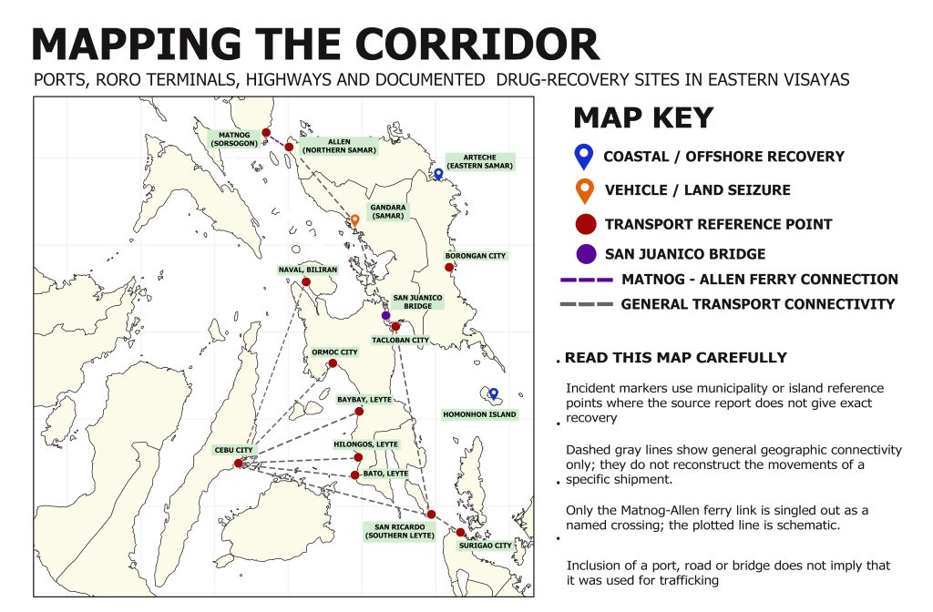
MAP DESIGN, RESEARCH AND DEVELOPMENT Research, mapping, and geographic visualization by Jazmin Bonifacio and Christian Ray Torres using Google Earth Pro and Google My Maps.Project: The Maritime Corridor: Drugs, the Sea, and Eastern Visayas’ Place in the Trafficking Route
The Vanguard | 2026© The Vanguard. All rights reserved.


 DOH Brings Free Healthcare to Mamanwa Communities in Samar
 Tacloban Police Extend Security Patrols Ahead of Yolanda Anniversary
 Eastern Visayas Abaca Contributes to Philippine Exports
 Drought, Power Shortages Threaten to Raise Utility Costs in Eastern Visayas
 Fruit vendor arrested in Tacloban buy-bust operation
 Tacloban Dispatcher Nabbed; P28,000 Suspected Shabu Seized